
Commerce Township Neighbor Sources by Block
Public records around a Commerce Township address answer different block questions. The county map identifies parcels and their geography. Municipal and county property systems can provide owner or tax information. Michigan election records have their own protected access rules, and historical directories identify a household head only at the time of publication. Association pages add community context, but a private member list is not a public block source.
| Source | What It Shows About a Block | Access |
|---|---|---|
| Oakland County Property Gateway | PIN, property address, map parcel, and adjacent polygons | Free search and map browsing; reports and maps may be paid |
| Commerce BS&A | Municipal property, tax, and permit search routes by address, name, or parcel | Public route; confirm available record fields with the township |
| Michigan voter records | Authorized status, precinct, and public voter-file fields | Individual status tool or formal QVF request, with redactions |
| Association community pages | Rules, events, maps, minutes, and a contact path | Public material varies; member directories are private or gated |
| OCPHS reverse directories | Historic household-head and phone clues by street and number | In-person or collection inquiry for dated volumes |
A tax owner is not automatically the person who occupies the address. The property's mailing address can also point away from the parcel. Label results as owner, parcel, public voter-record field, or historical directory entry rather than merging them into a claim about an entire present household.
Map a Commerce Township Neighbor Block
Oakland County's Property Gateway provides the documented parcel-to-block method. Search the target address or PIN, pan and zoom to the map, then click the polygon on each side and across the road. The research did not document a special adjacent-parcel or buffer button, so map navigation and parcel clicks are the supported method. Save the displayed PIN and situs address for each relation before using another record system.
The Oakland County Property Gateway source below shows the official parcel-map entry. Its search accepts a PIN or property address, with a five-character minimum and documented partial or wildcard examples.
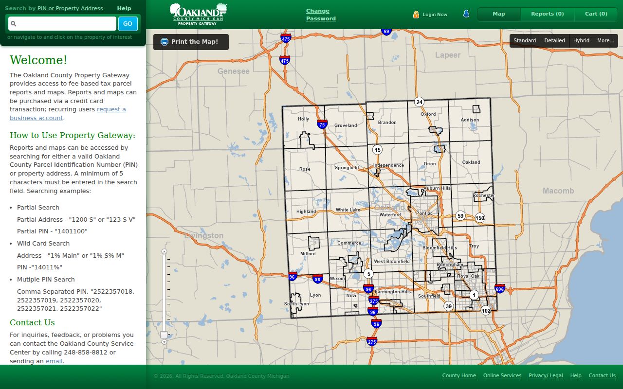
The map makes the geographic relationship visible, but it does not decide ownership or occupancy on its own. Once a neighboring parcel is selected, compare its PIN, situs address, and dated property record before drawing a conclusion about the block.
- Find the starting address in Property Gateway and record the displayed situs address, PIN, and Commerce municipality or CVT information.
- Click each nearby parcel in turn, noting the relation such as across-road, corner, or lakefront parcel rather than guessing from a distant map view.
- Check the selected PIN in Commerce BS&A or the recorded-deed index for the source-specific owner or instrument trail.
- Use the Commerce Township street directory when the question expands from the immediate block to a full named street.
Commerce Township Neighbor PIN Notes
A PIN is Oakland County's ten-digit property identifier. It is more stable than a postal-city label when a Commerce Township location is served through Walled Lake or Wixom mailing conventions. Keep the PIN with the source date, the exact address text, and the role shown by the record. A legal description can become the next bridge to the Oakland deed index if the street text is old or incomplete.
Property Gateway accepts partial PINs, wildcard addresses, wildcard PINs, and comma-separated PINs. Those options can help locate a parcel when only part of the address is known. They do not create a verified list of neighbors. Split a long block by intersection or short address prefix, then inspect each parcel one at a time.
Note: The owner mailing address is a tax-correspondence field and can be outside Commerce Township, so it should not replace the parcel's physical situs address.
Commerce Township Neighbor Voter Boundaries
Michigan voter registration records are public in defined ways, but the regular Michigan voter tool is for an individual's status and polling information, not an unrestricted block roster. The Michigan Department of State withholds driver-license and state-ID numbers, month and day of birth, and telephone number. A complete Qualified Voter File request is a formal process that should use a precise jurisdiction, precinct, date, or address scope.
Use Michigan.gov/Vote for its official status and polling route. Commerce elections identify precincts and local service locations, but a precinct is not a ZIP and a polling place is not evidence of a voter's address. The Michigan Address Confidentiality Program also protects eligible participants through designated-address procedures.
Commerce Township Neighbor Association Contacts
Association material can identify the social geography around a block without disclosing member names. The confirmed local sources publish items such as lake rules, bylaws, maps, public pages, meeting material, news, and community events. They are useful for a contact route or development clue, then the parcel and deed records can establish the authoritative property trail.
| Organization | Public Community Material | Directory Boundary |
|---|---|---|
| Lake Sherwood Homeowners Association | Lake information, rules and bylaws, map, contacts, newsletter, and events for the Lake Sherwood area | No public member roster located; use the public contact path |
| Woodbridge Lake HOA | Public pages, restrictions, meeting minutes, and financial material for Commerce Township | The member directory is a gated member function, not a public list |
| Golf Manor Subdivision Association | Community resources, news, events, and updates | No public resident roster located |
| Commerce Township DDA | Public board names, contact information, and meeting details | Civic board information is not a neighborhood directory |
Commerce Township lacks a confirmed township-wide association inventory. A community name can help identify a plat, lake, road, or meeting contact, but it should not be used as a substitute for a parcel boundary or permission to reproduce a private roster.
Commerce Township Neighbor Source Comparison
Official records describe their custodian, date, and limits. Commercial neighbor-lookup tools may combine public indexes, directory data, and purchased datasets, but their update cycle and matching process may be unclear. They can conflate names or addresses. Use the official parcel, court, or historical source to verify any lead and do not treat a compiled result as a full household account.
| Source Type | Best Use | Limit to Keep in View |
|---|---|---|
| Official parcel and deed records | Dated parcel, title, and recorded-instrument questions | Owner and mailing data do not establish every occupant |
| Official voter and court channels | Defined public status or docket questions | Protected fields, restricted cases, and formal request rules apply |
| Historical directories | Past household-head clues at a street number | Each edition is a dated snapshot, not a current roll |
| Commercial compiled tools | A supplemental lead to verify at the source office | Possible stale, merged, or incomplete household data |
Historic Commerce Township Neighbor Clues
The historic layer is best searched by street and house number. The Oakland County Pioneer & Historical Society holds North Oakland Criss-Cross directories from 1957, 1958, and 1960, plus a South Oakland Bresser cross-index for 1967–68. A criss-cross directory works from address to household head and may add a phone number, owner marker, first-year-listed note, or relocation clue depending on the edition.
Use a second dated source to test the historical clue. The OCPHS directory shelf also includes Commerce-named telephone directories from 1942/43 and 1944, while its obituary cards, maps, and newspapers can provide context. A historic address entry is evidence of a published listing at that time, not proof of a present Commerce Township neighbor.
Commerce Township Neighbor Map Context
Map scale matters on a block near a lake, road edge, or corner. Property Gateway's Print Map path offers paper options, print scale, PDF choices, and delivery or pickup options. Preserve the target parcel and adjacent PINs before changing scale. When the free map is not enough for a formal boundary question, Oakland County mapping services are the documented route for custom mapping support.
Property maps are current geography, not a complete historical reconstruction. For an older street spelling or postal label, compare the parcel with the legal description, a deed, a directory edition, or a township map. Commerce's local postal overlap means that a Walled Lake or Wixom mailing label should be verified against the county parcel and township field rather than assumed to be outside Commerce.
Commerce Township Neighbor Record Requests
When a public portal does not expose the needed field, ask the office that holds the record. A Commerce Township FOIA request to the Clerk should name a parcel, street address, record category, and date range. Michigan FOIA generally provides a five-business-day response with one possible ten-business-day extension, while courts follow their own rules. For historic block research, OCPHS and the Commerce Township Community Library are documented collection and access fallbacks.
Use an office request to seek a specific record, not a broad dossier on a block. The property map, a dated deed, a clerk file, or a historical directory has a defined role. That distinction makes the request more workable and limits the risk of drawing conclusions from records the office does not maintain.
Commerce Township Neighbor Privacy Limits
Private household members, non-owner occupants, utility accounts, delivery information, and protected addresses are outside the public block layer. Michigan's Address Confidentiality Program provides eligible participants with a designated address and mail forwarding. Public voter records also omit key identifiers, and sealed court material remains restricted. A blank map field or a missing search result can reflect a lawful limit rather than an error.
Lawful use. Commerce Township neighbor research is appropriate for personal, lawful questions, community context, family history, or safety awareness. Do not use a map, address, association contact, or record to watch, threaten, stalk, harass, or intimidate another person.